Mapping Indicates that 80% of England's Peatlands are Dry and Degraded
Mapping Indicates that 80% of England's Peatlands are Dry and Degraded

13/05/2025
The Department for Environment, Food, and Rural Affairs (Defra) reports that scientists have produced the most comprehensive map of England's peatlands and peaty soils to date using satellite imagery, artificial intelligence, and rigorous data analysis.
Surprisingly enough, recent mapping shows that 80% of the peatlands in England are degraded and dry.
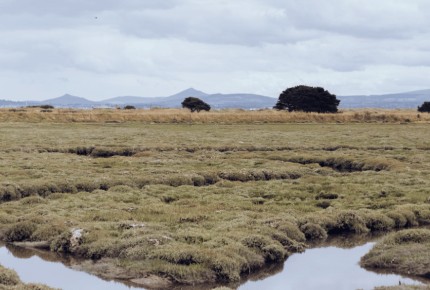
Condition & Health of England's Peatland
Launched on Monday, the open-source map, which includes vegetation, gullies, and both natural and man-made draining channels, models the extent, depth, and condition of England's peat.
In addition to lowering the risk of flooding and improving water quality, healthy peatlands can help address the climate crisis and provide habitat for rare species of dragonflies, golden plover, and curlews. Degraded peat, however, releases carbon into the atmosphere, which fuels global warming.
Peaty soil makes up about 8.5% of England's land area,
according to the map, with the largest peatland habitats found in the Pennines, North York Moors, portions of the Lake District, and the southwest uplands. Nevertheless, the study also discovered that 80% of the peatlands in England were dry and in poor condition.
Besides, only 1% of the peatlands were covered by significant peat-forming plants like sphagnum moss, according to the map, whereas the remaining 75% were covered by vegetation and land use types linked to drier conditions.
Dr Sallie Bailey, Natural England's chief scientist, stated, “Trying to map something that's largely underground, changes in volume depending on whether it's rained recently, and tries to swallow you up every time you set foot in it comes with its challenges, which makes this map extraordinary in its accomplishment and something of a global first.”
“Mapping peat to this level of detail will help us maximise the benefits of peat and massively advances our understanding of the role our peatlands are playing in a changing climate.”
Quantifying Peat Carbon Storage & Emissions
According to Defra, understanding the amount of peat in England is the first step in calculating how much carbon it holds and releases.
Moreover, ministers hope that the map will help land managers better understand and restore peatland by rewetting the land by blocking drainage channels, and that it will assist decision-makers in striking a balance between food security, biodiversity, and carbon storage.
Notably, Tony Juniper, chair of Natural England, highlighted the significant benefits of healthy peatlands, including their role as natural carbon stores, water cycle essentials, and habitats for rare plants and wildlife like sundew plants, marsh violets, and
charismatic birds like golden plovers and curlews.
Further, he noted that the England peat map will aid in better decision-making regarding peatlands management, focusing restoration efforts on degraded peat and identifying optimal opportunities for nature recovery.
Ultimately, Caroline Thorogood, the National Trust's lead for peatlands, has announced that the data from the map will aid in accurately mapping peatlands in England, enabling better identification of priorities and future work to recover these precious areas, which provide benefits like carbon storage and water regulation.
Read more news:
Elon Musk claims that a "massive cyberattack" caused waves of outages on his X
TikTok 'Craze' Caused Peak District's Severe Parking Situation
Microsoft will shut down Skype in May after nearly two decades